データのカテゴリー
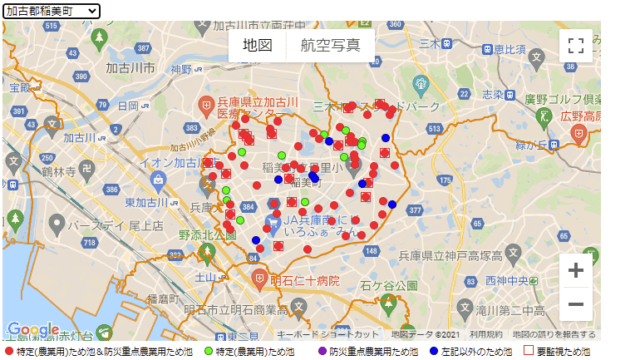
ため池区分
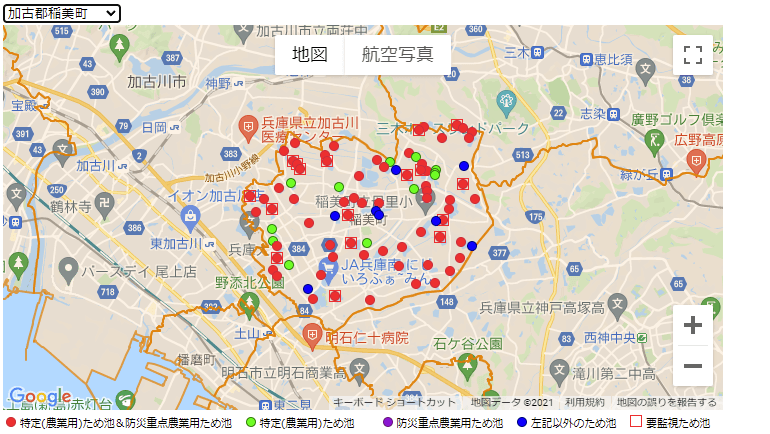
兵庫県の公表ため池CSVデータの区分(カテゴリー)を見ると、県の指定状況から、特定(農業用)ため池、防災重点農業用ため池及びこれら以外のため池に分類できる。さらに、兵庫県水防計画書には、要監視ため池の指定が掲載されている。
マーカー区分
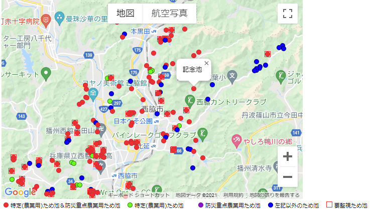
ため池の地図表示を以下のような区分とマーカーで試した。
| 区分 | マーカー | コード中のファイル名 |
| 特定(農業用)ため池 | circle-greenlime10px.png | |
| 防災重点農業用ため池 | circle-purpleviolet10px.png | |
| 特定(農業用)ため池かつ防災重点農業用ため池 | circle-dredred10px.png | |
| 上記以外のため池 | circle-navyblue10px.png | |
| 要監視ため池 | square-red12px.png |
マーカーの凡例表示
HTMLの14~22行目を書き足し、地図の欄外下部に凡例を設ける。
<!DOCTYPE html>
<html lang="ja">
    <head>
        <meta charset="utf-8">
        <title>Nishiwaki Reservoirs Map Gmap</title>
        <link rel="stylesheet" href="./style-practical-01.css">
        <script src="./index-practical-05.js"></script>
        <script src="https://ajax.googleapis.com/ajax/libs/jquery/3.6.0/jquery.min.js"></script>
    </head>

    <body>
        <div id="map"></div>
        <div style="display:inline-block;margin:4px;font-size:11px;">
            <span>
                <img src="../picture/circle-dredred10px.png"> 特定(農業用)ため池&防災重点農業用ため池
                <img src="../picture/circle-greenlime10px.png"> 特定(農業用)ため池
                <img src="../picture/circle-purpleviolet10px.png"> 防災重点農業用ため池
                <img src="../picture/circle-navyblue10px.png"> 左記以外のため池
                <img src="../picture/square-red12px.png"> 要監視ため池
            </span>
        </div>
        <script async defer src="https://maps.googleapis.com/maps/api/js?key=Your_API_Key&callback=initMap&libraries=places&v=weekly"></script>
    </body>
</html>
ため池の区分とマーカーの照応
ため池の区分に応じたマーカーを表示するため、JavaScriptの28~45行目を追加変更。
GeoJSONファイルの特定(農業用)ため池指定日、防災重点農業用ため池指定日、要監視ため池の各propertiesの記述の有無を判定条件とした。
let map;

function initMap() {
    map_options = {
        zoom: 12,
        mapTypeId: google.maps.MapTypeId.ROADMAP,
        center: {lat: 35.015, lng: 134.995},
        streetViewControl: false,
        mapTypeControl: true,
        mapTypeControlOptions: {
            position: google.maps.ControlPosition.TOP_CENTER,
        },
    }
    map_document = document.getElementById('map')
    map = new google.maps.Map(map_document,map_options);
    loadMarkers();
}

//ため池マーカー
function loadMarkers() {
    geojson_url = '../geojson/nishiwaki_2138.geojson'
    $.getJSON(geojson_url, function(results) {
        data = results['features']
        for (let i=0; i < data.length; i++) {
            let coords = results.features[i].geometry.coordinates;
            let latLng = new google.maps.LatLng(coords[1], coords[0]);
            let rname = results.features[i].properties['ため池名'];
            let tokutei = results.features[i].properties['特定(農業用)ため池指定日'];
            let boujuu = results.features[i].properties['防災重点農業用ため池指定日'];
            let kanshi = results.features[i].properties['要監視'];

        let iconopt='';
        if (tokutei != "" && boujuu != "" && kanshi == ""){
            iconopt = '../picture/circle-dredred10px.png';
        } else if (tokutei != "" && boujuu != "" && kanshi != ""){
            iconopt = '../picture/sqcir-red12px.png';
        } else if (tokutei == "" && boujuu != "" && kanshi == ""){
            iconopt = '../picture/circle-purpleviolet10px.png';
        } else if (tokutei == "" && boujuu != "" && kanshi != ""){
            iconopt = '../picture/sqcir-purple12px.png';
        } else if (tokutei != "" && boujuu == "" && kanshi == ""){
            iconopt = '../picture/circle-greenlime10px.png';
        } else if (tokutei == "" && boujuu == ""){
            iconopt = '../picture/circle-navyblue10px.png';
        }

        //マーカーを生成
            let marker = new google.maps.Marker({
                position: latLng,
                map: map,
                icon: iconopt,
            });

        //情報ウインドウの生成とクリックイベント関数の登録処理
        setMarkerListener(marker);

            function setMarkerListener(marker) {
            //情報ウインドウの生成
                let infoWindow = new google.maps.InfoWindow({
                    content: rname,
                });
            //マーカーのマウスクリックで情報ウインドウを表示
                google.maps.event.addListener(marker, 'click',function(event) {
                    infoWindow.open(map,marker);
                });
            //マーカーのマウスアウトで情報ウインドウを消去
                google.maps.event.addListener(marker, 'mouseout',function(event) {
                    infoWindow.close();
                });
            }
        };
    })
}